
Pershing Highway: The Road That Connected DeLand to the World
Long before the hum of traffic along modern highways, the journey between DeLand and Daytona Beach was slow, muddy, and unpredictable. What is now a quick 20-minute drive once took nearly a full day, if you were lucky enough to make it through the swamps at all.
Then came Pershing Highway, a narrow strip of brick that forever changed how Central Florida moved, traded, and grew.
Before the Highway: A Journey Through Sand and Swamp
In the early 1900s, there was no true road connecting the two cities, only sandy trails cutting through wetlands and dense forest. Travelers had to navigate areas like Tiger Bay, often battling mud, mosquitoes, and water crossings. A round trip could take up to 12 hours, and in some cases, even longer.
For a region trying to grow, economically and socially, this lack of infrastructure was a serious problem.
Building a Modern Marvel (1917)
Everything changed in 1917, when construction began on what would become Pershing Highway, the first improved road linking DeLand and Daytona Beach.
Built primarily from red brick and cutting straight through forests and swampland, the road was a major engineering feat for its time. It was narrow, just a single lane in many places but it offered something revolutionary: reliability.
For the first time, people could travel between the inland county seat and the coast without depending on weather or terrain.
A Name with National Pride
In 1918, the road was officially named “Pershing Highway” in honor of John J. Pershing, a national hero of World War I.
The name reflected more than patriotism, it symbolized progress. Across the country, improved roads were beginning to reshape travel, and Volusia County was stepping into that new era.
The highway also became part of a larger network known as the “Pershing Triangle,” connecting DeLand, Daytona Beach, and New Smyrna Beach, one of the earliest regional highway systems in Florida.
Life on the Brick Road
Driving Pershing Highway wasn’t exactly smooth. The brick surface created a constant “clackety-clack” under tires, and shifting sand beneath the bricks caused uneven sections. Still, for early motorists, it was a massive upgrade.
In the 1920s, improvements were made, adding concrete shoulders to allow two vehicles to pass. Along the route, small roadside stops appeared: orange stands, gas pumps, and rest points for travelers making the journey between inland farms and the growing beachside destination.
During World War II, the road even served a patriotic role, with locals picking up sailors from the nearby naval air station who were hitchhiking toward the coast.
The Beginning of the End
As automobiles became more common and traffic increased, Pershing Highway began to show its limitations. It was too narrow, too fragile, and too slow for the demands of modern travel.
By the mid-20th century, a new route, what would become U.S. Highway 92, replaced it.
And by 1947, Pershing Highway was officially abandoned as the primary route between DeLand and Daytona Beach. What was once a vital artery of travel quickly faded into obscurity.
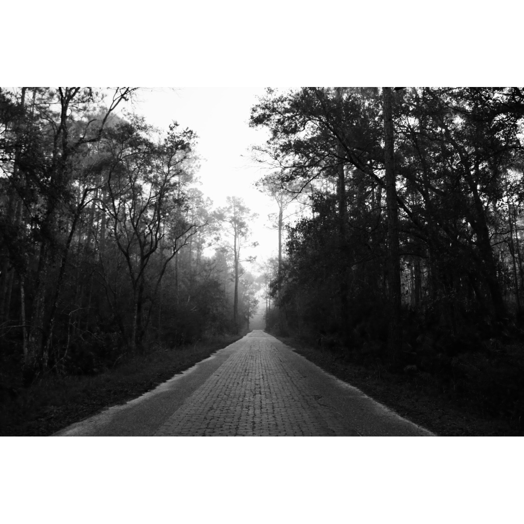
Rediscovered in the Woods
Today, remnants of Pershing Highway still exist, hidden within Tiger Bay State Forest.
Sections of the original brick road remain intact, preserved as interpretive trails where you can literally walk through history.
Surrounded by pine flatwoods and swamp, the road feels almost surreal, like stepping into a forgotten version of Florida, where the pace was slower and the journey mattered as much as the destination.
Further Reading:


TITLE: The Way Forward
LOCATION: Daytona Beach, Florida, United States
Print sizes available include 5"x7", 8"x10", and 11"x14".
Options include black or white mat board. If ordering a print with mat the outer will be larger.
Print Size: 5"x7"/ Outer Mat Size: 8"x10"
Print Size: 8"x10"/ Outer Mat Size: 11"x14"
Print Size: 11"x14"/ Outer Mat Size: 16"x20"